Florida’s terrestrial land mass has been reduced by roughly 50 percent since the height of the Glacial Maximum, approximately 22,000 years ago. Today, the modern Gulf Coast of Florida lies in some places over 300 km landward from the maximum extent of its Pleistocene shoreline.
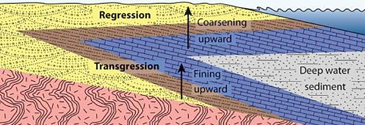
Current evidence for the earliest human presence in Florida dates to approximately 14,550 years ago (Halligan et al. 2016), a time when the coastal position was roughly 200 km seaward from today’s northern Gulf Coast. The position of the coast continued to move in a landward direction over the next 10 millennia until approximately 5,000 years ago, when sea level would slowly begin to “stabilize.” New models suggest that the shoreline at the beginning of the most recent interval of transgression (~5,000 years ago) was located approximately 25 km from the present-day shoreline. Archaeological evidence from across the globe suggests that humans were reaping the benefits of maritime subsistence economies thousands of years before the initial peopling of the New World. Might there have been a coastal presence along the northern Gulf Coast of Florida before this most recent transgression, which is now submerged beneath the sea? If so, is it possible that evidence of early coastal use has been preserved by accumulated sediment and favorable geochemical conditions?
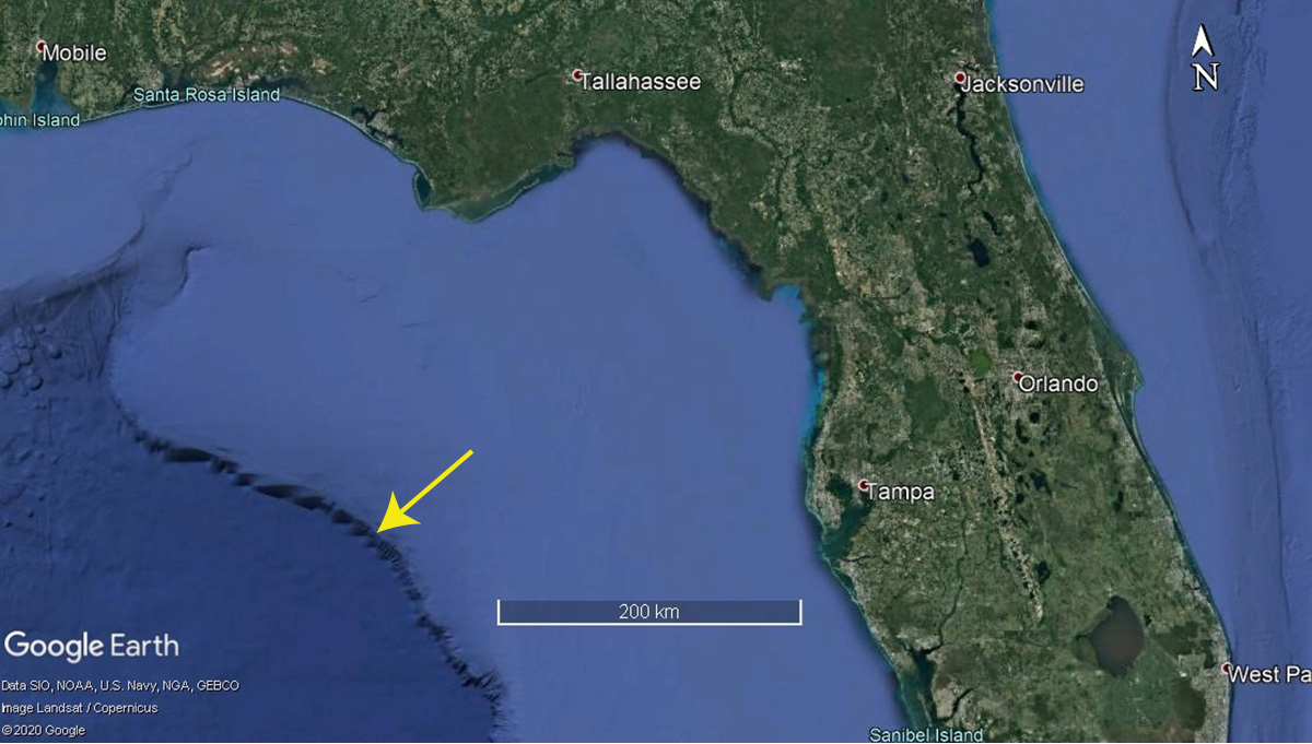
Several underwater sites have been investigated offshore of Florida’s Big Bend region along the Paleo-Aucilla and Paleo-Econfina channels (Faught 2004), and more recent research (Duggins 2012) has highlighted the potential for locating offshore archaeological sites in other portions of Florida’s Gulf Coast. Because archaeological sites on the submerged continental shelf may predate inland sites in the area, knowing when and how these sites were occupied is critical to our understanding of the impacts of changing sea levels on the lives of native people. However, these sites are difficult to locate and investigate.
Despite the relatively stable conditions of the Gulf shoreline since about 5,000 years ago, sea level has continued to rise and is now amplified by anthropogenic activities. Climatic data show that since the onset of the Industrial Revolution, our planet has experienced accelerated rates of meltwater inputs, and scientists now project a rise of over 2.3 meters for every 1 C of atmospheric temperature increase (Parkinson et al. 2014). Furthermore, the low gradient of the Gulf Coast contributes to its vulnerability to submersion. Click this link to view the National Oceanic and Atmospheric Administration’s (NOAA) Sea Level Rise Simulator. Sea level rise, or, sea level transgression, has been a topic of intense discussion in recent decades and we might expect the dialogue to increase in coming years, as the cycle continues.
How does archaeology stand to contribute to greater anthropological questions pertaining to settlement configurations, human responses to environmental catastrophes, and interventions people made to mitigate the effects of sea level rise? Our answer is a boatload. However, submerged sites present a slew of logistical challenges. One glaring challenge is the amplified “needle in a haystack” nature of locating archaeological sites in offshore contexts. Luckily, modern remote sensing techniques have the potential to improve the ability to discover and characterize these elusive cultural resources.
Remote sensing may be broadly defined as “non-destructive or non-invasive means for investigating and displaying geospatial data.” Geospatial remote sensing formed the backbone of NASA’s Space Program long before it was accessible to researchers in other disciplines. Today, a common example of remote sensing is the use of Google Earth or Google Maps, where anyone can see most, but not all, of the physiographic features present on the surface of the Earth, as transmitted by a series of satellite constellations constantly in orbit. In recent years, satellite sensing technology has moved beyond the surface of the Earth and into water bodies, becoming an addition to underwater archaeology’s battery of imaging techniques alongside side-scan sonar, sub-bottom profilers, green LiDAR, and multi-beam echosounders.
The Paleo-Suwannee Project is part of my dissertation research, which aims to improve scientific knowledge of prehistoric archaeological sites along the Gulf Coast of Florida and provide insights into the lifeways of former coastal communities. The project will also serve as a proof-of-concept for using satellite remote sensing to identify potential locations of underwater cultural heritage sites, and for using seafloor characteristics to predict their locations. Comparing lower-resolution satellite-derived bathymetry with higher-resolution ship-based bathymetry will help us understand the role played by spatial scale in underwater archaeology and marine habitat mapping. Additionally, the project will also provide high-resolution marine geomorphological and habitat map products that can inform management, sustainable use, and conservation of marine resources.
Matthew A. Newton
July 2020
References Cited
Duggins, Ryan
2012 Florida’s Paleoindian and Early Archaic: A GIS Approach to Modeling Submerged Landscapes and Site Distribution on the Continental Shelf. Ph.D. Dissertation. Florida State University. Tallahassee.
Faught, Michael K.
2004 The Underwater Archaeology of Paleolandscapes, Apalachee Bay, Florida. American Antiquity 69:275–289.
Halligan, Jessi J., Michael R. Waters, Angelina Perrotti, Ivy J. Owens, Joshua M. Feinberg, Mark D. Bourne, Brendan Finnerty, Barbara Winsborough, David Carlson, Daniel C. Fisher, Thomas W. Stafford and James S. Dunbar
2016 Pre-Clovis occupation 14,550 years ago at the Page-Ladson site, Florida, and the Peopling of the Americas. Science Advances 2:1–8.
Klein, Cornelis, and Anthony Philpotts
2013 Earth Materials: Introduction to Mineralogy and Petrology. Cambridge University Press, Cambridge.
Parkinson, Randall W., Peter W. Harlem, and John F. Meeder
2015 Managing the Anthropocene Marine Transgression to the Year 2100 and beyond in the State of Florida U.S.A. Climatic Change 128:85–98.